Software Projects
AIDE: the Annotation Interface for Data-driven Ecology
If one or more of the following points sound familiar to you:
- You have got thousands, perhaps millions of images, but no or only few annotations (bounding boxes, labels, etc.).
- You tried to label parts yourselves with simple, passive tools and quickly gave up due to the frustration and tedium it caused.
- You have heard of those fancy computer vision algorithms (deep neural networks), but have no experience or proper setup to employ them.
- Maybe you have even heard of human-in-the-loop systems that make such algorithms work hand-in-hand with humans.
- Or, you actually do employ your own machine learning algorithm, but are tired of writing lots of boilerplate codes to handle the data and models.
Then AIDE might be your answer, because it solves all of the above!
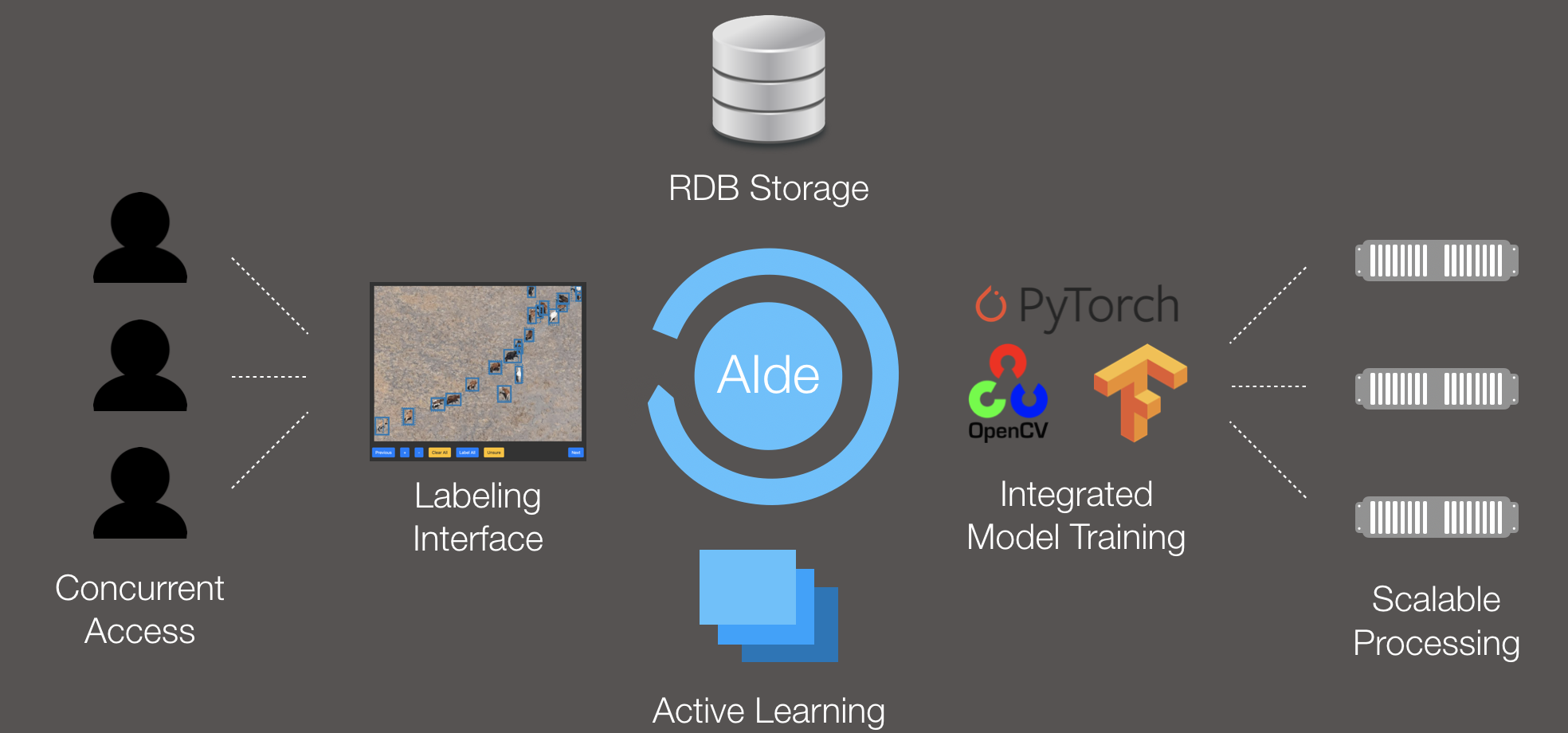
AIDE is a web-based annotation service that combines a highly versatile labeling platform with a sophisticated machine learning model, to accelerate and improve your labeling process in every way. To the best of my knowledge, it is the first general-purpose interface ever to include humans and a model with an Active Learning loop.
Background
AIDE was born as part of my internship program at Microsoft Research in the AI for Earth initiative. The initial focus of the platform was on animal detection from aerial images, but
the framework can in principle be used for virtually anything requiring (image) labels.
In essence, this means that AIDE is a Microsoft-backed project that will continue to be developed.
Highlights
AIDE features some exciting properties:
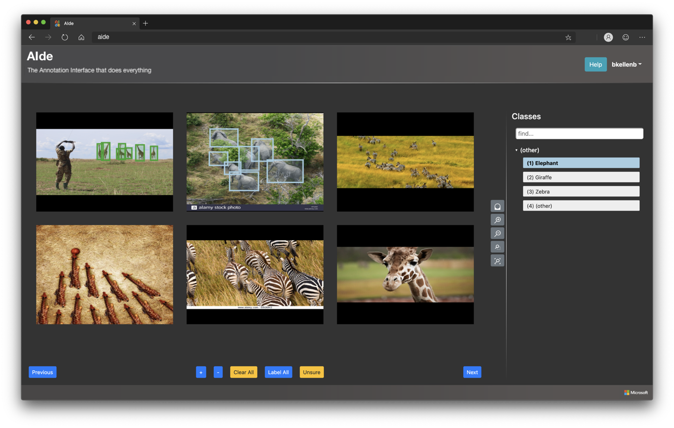
- Support for all kinds of annotations: image labels, points, bounding boxes, and semantic segmentation maps.
- State-of-the-art machine learning / computer vision model in the background, assisting users and learning from them as they move along. AIDE ships with some sophisticated, deep learning-based models built-in.
- High security and safety: password authentication, relational database (RDB) storage.
- Extreme concurrency and scalability: support for multiple users providing labels simultaneously, parallel and distributed model training, possibility of adding new servers on-the-fly.
- Top-to-bottom customisability: everything can be configured to your needs. You can even provide your own AI model if you happen to have one.
- AIDE allows training and evaluating deep learning models in a highly flexible manner. Model states can even be shared with other projects and other people for maximal interoperability!
Sounds useful, but can I try it?
Sure, we have a few demo instances running that showcase the user interface:
- Image labels on the Snapshot Serengeti camera traps dataset
- Points on the VGG Penguins dataset
- Bounding boxes on the NOAA Arctic Seals aerial imagery
- Semantic segmentation on the Chesapeake Land Cover satellite imagery
Interested in a sneak peek for the upcoming v3? Here's a demo with awesome new semantic segmentation tools:
- Semantic segmentation on the Inria Aerial Image Labeling dataset
- Semantic segmentation on the ACDC (street-level images) dataset
Remember: these demos just display the labeling frontend; in reality you would also have a model working hand-in-hand with the users.
Great, how can I get it?
Here's the best part: AIDE is fully Open Source and can be downloaded for free from the corresponding GitHub page!
Big update: I am working on the next version (v3) of
AIDE, with lots of new features to come! Implemented:
Photoshop-grade semantic segmentation tools (see demos above),
polygon annotations, support for multi- and hyperspectral
images, support for new image formats (ERDAS Imagine, ENVI,
DICOM, etc.). Guaranteed but work in progress: advanced
annotation im- and export. Other new features are TBD.
But I don't have the required infrastructure!
Are you by chance working on an Earth science or conservation project? Then head over to the Microsoft AI for Earth project site and apply for computation credits for the Microsoft Azure cloud! Or, alternatively, drop me a line and I may be able to arrange something for you. AIDE works wonderfully on Azure—in fact, it has been developed on it.
I have a great model, good idea, etc., can I contribute?
Yes, please! Although I am the only developer on the product at this moment, I would like AIDE to turn into a proper collaborative project. If you have:
- a useful AI model,
- a great idea you would like to implement (or see implemented),
- suggestions for improvement,
- found bugs or issues,
- or just general feedback,
I would be more than happy to hear from you. Remember: AIDE is open source on Github, so you can start contributing or branching right away.
Thank you!
GeoVITe: Geodata viewer and download portal
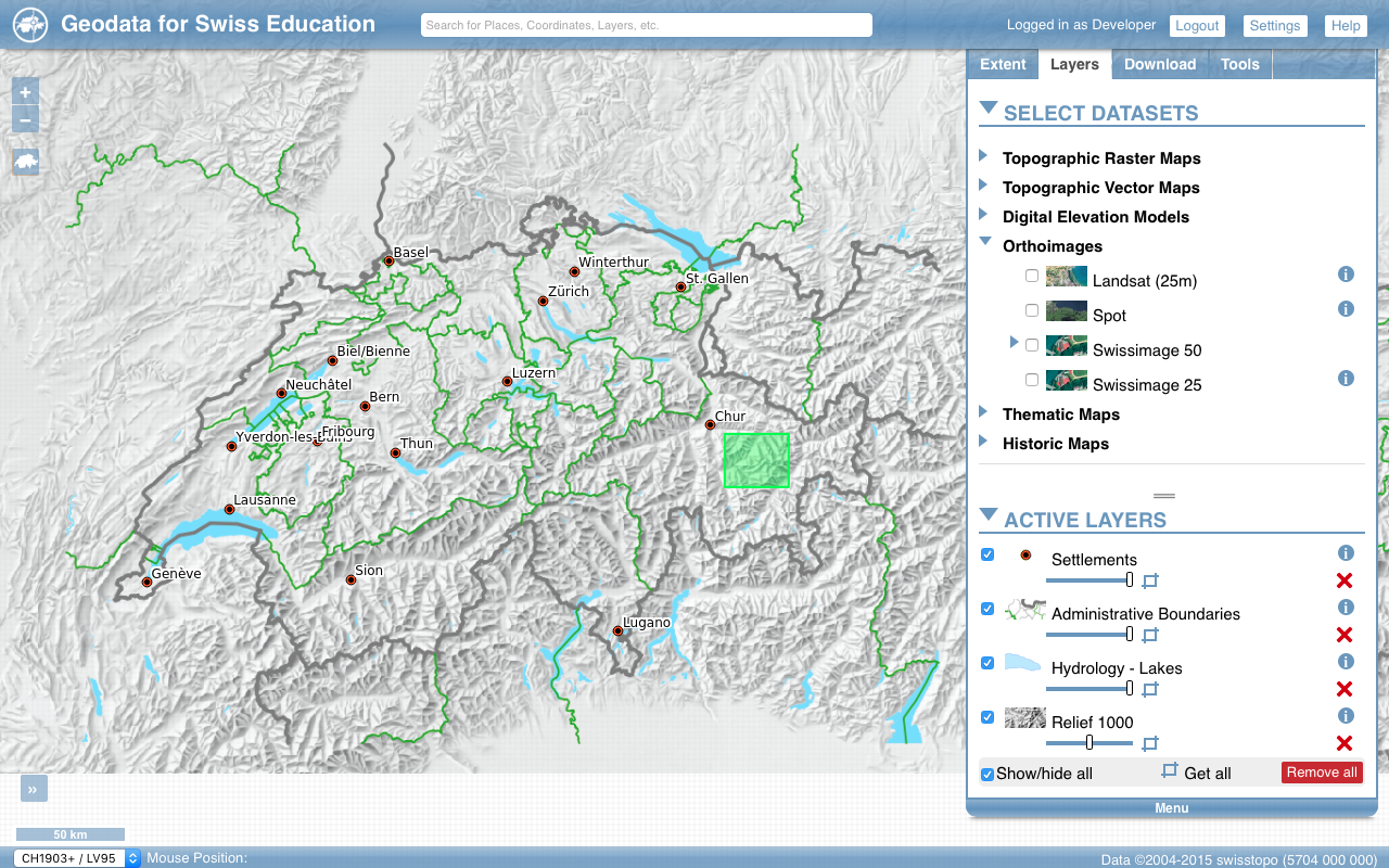
GeoVITe is a scalable, web-based geospatial data viewer and download service provided by the Institute of Cartography and Geoinformation (IKG), ETH Zurich, Switzerland. GeoVITe allows academic institutions with a subscription to view and download the full geospatial data catalogue provided by swisstopo by means of bounding box selections. During my internship at IKG in 2015/16 I developed most of the GeoVITe engine (full stack), including:
- Web front-end (user interface)
- Server backend (incl. full geodata selection and download functionalities)
- RDB connection
- Vector Tiles server. GeoVITe contains one of the first, custom, and configurable GeoJSON-based server backend for vector tiles. The system uses PostGIS's functionalities for on-the-fly generalization (fully customizable). It even implements a smart caching system, which means that the more the service is used, the faster it gets!
I also presented a beta of the platform at EuroCarto 2015 and released a paper on it soon after.